Vinaora Nivo Slider 3.x

Over NAF. 290.000 in fines issued in first half of 2016.

boetekaart04082016
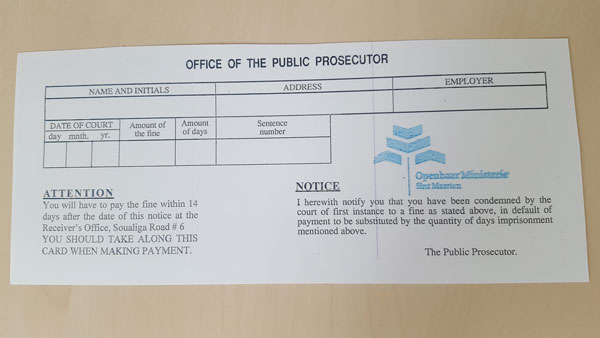
PHILIPSBURG:--- In the first six months of 2016 a total of Naf. 190,316 in fines, issued by the St. Maarten Police Force (KPSM), have been collected. This is an increase of more than 150 percent compared to the same period in 2015 when only Naf. 73,600 in fines had been collected.

In total, KPSM issued Naf. 291,500 in fines in the first half of this year. This is partly due to tighter traffic controls by Police. This amount is also significantly more than the Naf. 188,500 in fines issued by Police in the same period last year. 

More than half of the total amount of fines collected in the first six months of this year, some Naf. 100,000, is due to the tighter Police traffic controls. During these controls, the police summoned those with an outstanding fine to immediately render payment.

Moreover, the Prosecutor’s Office is catching up with the backlog in uncollected fines. Residents with outstanding fines are urged to pay this as soon as possible to avoid additional costs. Non-payment of outstanding fines may also result in an alternative sentence in prison. For every Naf. 50 worth in outstanding fines, one day in prison can be levied for non-payment.

Fines can be paid at the counter of the Receiver’s Office on Soualiga Road 6, at Police Headquarters on E. Camille Richardson Street 24 (only debit card) and at the Prosecutor’s Office at the Vineyard Building, Buncamper Road 33 (only debit card ).

Persons with outstanding fines must first visit the Prosecutor’s Office to receive confirmation of the exact amount to be paid.

Meer dan NAf. 290.000 aan boetes uitgeschreven gedurende eerste zes maanden van 2016

Gedurende de eerste zes maanden van 2016 is in totaal Naf 190,316 aan boetes geïnd. Vergeleken met 2015 toen in de eerste zes maanden NAf 73.600 is geïnd, is dit een toename van meer dan 150 procent. Het betreft boetes die door het Korps Politie van St.

Maarten (KPSM) zijn uitgeschreven. In totaal heeft KPSM gedurende de eerste zes maanden van dit jaar NAf 291.500 aan boetes (oproepingsprocesverbaal) uitgeschreven. Dat is ook beduidend meer dan het bedrag van NAf. 188.500 dat in de eerste helft van
2015 door KPSM is uitgeschreven aan oproepingsprocesverbalen. Dit komt onder meer
door scherpere controles door KPSM.

Meer dan de helft van het reeds geïnde bedrag, ongeveer NAf. 100.000, is ook het gevolg van de scherpere controles van de politie. Personen met een openstaande boete worden door de politie gesommeerd om direct over te gaan tot betaling.

Daarnaast is het Openbaar Ministerie bezig met een inhaalslag voor wat betreft nog niet geïnde boetes. Burgers met een openstaande boete worden opgeroepen om deze te betalen. Betaal op tijd en vermijd extra kosten. Bij niet betaling van openstaande boetes kan dit ook een vervangende hechtenis in de gevangenis ten gevolge hebben. Voor iedere 50 gulden aan openstaande boete moet 1 dag worden uitgezeten.

Boetes kunnen worden betaald bij het loket van de Ontvanger aan de Soualiga Road 6, bij het loket van het hoofdbureau van de Politie aan de E. Camille Richardson Street 24 (alleen pinbetaling) en bij het loket van het Openbaar Ministerie in de Vinneyard Building, Buncamper Road 33 (alleen pinbetaling).

Personen met een openstaande boete moeten eerst bij het Openbaar Ministerie langs om een boetekaart te krijgen met het juiste bedrag dat voldaan moet worden.


Stormy conditions expected as early as Thursday evening.

tsivette04082016
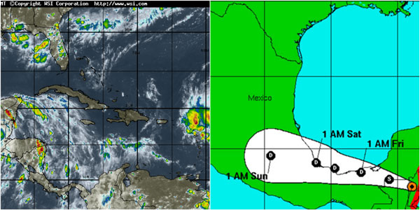
The 2016 Atlantic hurricane season is a current event in the annual tropical cyclone season in the northern hemisphere. The season officially begins on June 1, 2016, and will end on November 30, 2016. These dates historically describe the period each year when most tropical cyclones form in the Atlantic basin and are adopted by convention. However, as illustrated by Hurricane Alex and Tropical Storm Bonnie, the formation of tropical cyclones is possible at any time of the year. This season started exceptionally early, nearly five months before the official start, with Hurricane Alex forming in the Northeastern Atlantic in mid-January. Tropical Storm Bonnie followed in late May, which was the first occurrence of two pre-season Atlantic storms since 2012 and only the third occurrence since 1951.

To this point, most forecasting groups have called for this season to be a near average to above average season, due to a combination of factors including an expected transition to La Niña and warmer than normal sea surface temperatures in the Gulf of Mexico, Caribbean, and Western Atlantic, despite near-average sea surface temperatures in the Atlantic Main Development Region near Cape Verde.

Seasonal Forecast
Predictions of tropical activity in the 2016 season
Source Date Named Hurricanes Major
NOAA Avg (1981–2010) 12.1 6.4 2.7
Record High 28 15 7
Record Low 4 2 0

TSR 16 Dec 2015 13 5 2
TSR 5 Apr 2016 12 6 2
CSU 14 Apr 2016 13 6 2
NCSU 15 April 2016 15-18 8-11 3-5
UKMO 12 May 2016 14 8 NA
NOAA 27 May 2016 10-16 4-8 1-4
TSR 27 May 2016 17 9 4
Ahead of and during the season, several national meteorological services and scientific agencies forecast how many named storms, hurricanes and major hurricanes will form during a season and/or how many tropical cyclones will affect a particular country. These agencies include the Tropical Storm Risk (TSR) Consortium of the University College London, the National Oceanic and Atmospheric Administration (NOAA) and Colorado State University (CSU). The forecasts include weekly and monthly changes in significant factors that help determine the number of tropical storms, hurricanes, and major hurricanes within a particular year. Some of these forecasts also take into consideration what happened in previous seasons and the predicted weakening of the 2014–16 El Niño event. On average, an Atlantic hurricane season between 1981 and 2010 contained twelve tropical storms, six hurricanes, two major hurricanes, and an accumulated cyclone energy (ACE) index of 66–103 units.

The first forecast for the year was issued by CSU on December 10, who anticipated that one of four different scenarios could occur. TSR subsequently issued their first outlook for the 2016 season during December 16, 2015 and predicted that activity would be about 20% below the 1950–2015 average, or about 15% below the 2005–2015 average. Specifically they thought that there would be 13 tropical storms, 5 hurricanes, 2 major hurricanes and an ACE index of 79 units. A few months later, TSR issued their second prediction for the season during April 6, 2016 and lowered the predicted number of named storms to 12 but raised the number of hurricanes to 6. On April 14, CSU predicted that the season would be near-normal, predicting 13 named storms, 6 hurricanes and 2 major hurricanes with ACE near 93. On April 15, North Carolina State University predicted the season would be very active, with 15-18 named storms, 8-11 hurricanes and 3-5 major hurricanes. A month later, the United Kingdom Met Office (UKMO) released its forecast, predicting a slightly above-average season with 14 named storms and 8 hurricanes. It also predicted an ACE index of 125, being the average ACE index 103. On May 27, NOAA issued its first outlook calling for a near-normal season with a 70% chance that the atlantic could see 10-16 named storms, including 4-8 hurricanes of which 1-4 could reach major hurricane status. NOAA also stated that there is a 45% chance of a near-normal season, 30% chance of an above-normal season and 25% chance of a below-normal season. Also on May 27, TSR substantially increased their forecast numbers, predicting activity would be about 30% above the average with 17 named storms, 9 hurricanes, 4 major hurricanes and an ACE near 130. The reason for the increased activity forecast was the increased likelihood of La Niña forming during the season in addition to a trend towards a negative North Atlantic Oscillation, which generally favors a warmer tropical Atlantic. TSR predicted that there is a 57% chance that the 2016 Atlantic season would be above-normal, a 33% chance it would be near-normal, and only a 10% chance it would be below-normal.

2016 Storm Names
The following list of names will be used for named storms that form in the North Atlantic in 2016. Retired names, if any, will be announced by the World Meteorological Organization in the spring of 2017. The names not retired from this list will be used again in the 2022 season. This is the same list used in the 2010 season, with the exception of Ian and Tobias, which replaced Igor and Tomas, respectively.
Alex,Bonnie,Colin,Danielle,Earl,Fiona,Gaston,Hermine,Ian,Julia,Karl,Lisa,Matthew,Nicole,Otto,Paula,Richard,Shary,Tobias,Virginie,Walter.

Earl makes landfall in Belize, weakens to tropical storm.

earlpath04082016
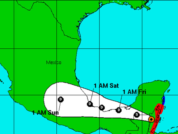
Update: Aug. 4, 10 a.m.

Hurricane Center: Earl weakens to a tropical storm as it moves inland after making landfall in Belize.

Update, Aug. 4

Hurricane Earl made landfall in Belize overnight, with sustained winds estimated at 80 miles per hour.

A hurricane warning is in place for Belize and parts of Mexico, though the storm was expected to begin weakening when it moved ashore. The hurricane center says heavy rains will be a danger in southern Mexico through Saturday as Earl crosses the Yucatan Peninsula and the states of Tabasco and Veracruz.

In Belize, the government opened storm shelters and used radio and television broadcasts to urge residents of low-lying areas to move to higher ground.

At 4 a.m. Thursday, the center of Earl was located at 17.3 degrees north and 88.9 degrees west. It was moving west at 15 miles per hour with maximum sustained winds of 75 miles per hour and a minimum central pressure of 982 millibars.

Update, 5 p.m.:

Tropical Storm Earl has been upgraded to a hurricane as it nears the coast of Belize, according to the National Hurricane Center.

At 5 p.m., the center of Earl was located at 17.1 degrees north, 86 degrees west. It was moving west at 14 mph with maximum sustained winds of 75 mph and a minimum central pressure of 988 millibars.

The center of Earl will likely make landfall overnight.

Update, Aug. 3

BELMOPAN, Belize - Tropical Storm Earl neared hurricane force Wednesday as it bore down on the Bay Islands of Honduras and the Caribbean nation of Belize.

The U.S. National Hurricane Center in Miami said that Earl was threatening to bring heavy rains, flooding and high winds to Mexico, Belize and Honduras, and was likely to blow past Honduras’ Roatan Island, a popular tourist destination, on Wednesday afternoon.

In Belize, the government opened storm shelters and used radio and television broadcasts to urge residents of low-lying areas to move to higher ground. The shelters were still empty on Wednesday morning, however.

FLORIDA TODAY
Download Hurricane Hub tracking app

The government’s chief meteorologist Dennis Gonguez, said the storm should begin affecting the country around 6 p.m. local time and will likely make landfall as a Category 1 hurricane.

Long lines of traffic formed at gas stations around the country as residents filled their tanks in advance of Earl’s arrival. Stores were also busy with people buying water and food.

At The Palms Oceanfront Suites in San Pedro on Ambergris Caye, Ana Ico said the hotel began preparing two days ago and gave guests the option to evacuate to the mainland or stay at the hotel. About 12 guests have chosen to stay, Ico said.

“Some of them have decided to stay so what we’re doing is we’re giving them some water, flashlights and informing them as we get updated on the storm,” she said. Other guests chose to move to the mainland.

Download FLORIDA TODAY's Hurricane Hub app, for the latest tropical weather news, tracking map and weather alerts: iPhone | Android

Belize, Mexico and Honduras issued tropical storm warnings for some areas, and a hurricane warning was issued for part of Mexico.

The airport on diving destination Roatan off the coast of Honduras closed its airport Wednesday as heavy rains moved in.

On Sunday, Earl was a weaker tropical wave but knocked down power lines and started a fire that killed six passengers on a bus in the Dominican Republic.

Late Wednesday morning, the storm was centered about 120 miles (195 kilometers) east of Roatan, with maximum sustained winds near 70 mph (110 kph) and was moving west near 14 mph (22 kph).

General Permit Measures of Order and Code of Conduct (for Election Campaign 2016).

edisonkirindongo11052016GENERAL CONDITIONS

In connection with the elections for the members of Parliament of St. Maarten, which will take place on Monday, September 26th, 2016, the Minister of Justice proclaims that all registered political parties will have to adhere to these GENERAL CONDITIONS, MEASURES of ORDER and CODE OF CONDUCT.

All registered political parties:

a. Must designate a person as their contact person, to the police and
b. May, according to the below-mentioned traffic and order measures, during the election campaign
1. Organize political manifestations and
2. To place advertising material (posters, flags and such signs) on or to the public road

- The period of the election campaign is scheduled to be from Monday, August 8th, 2016 up to and including Saturday, September 24th, 2016.
- Political activities are allowed only in the abovementioned period.
- Publicity billboards, which are posted on, or alongside the public road, may not exceed 6 m x 6 m (20 ft x 20 ft), considering that we are in the hurricane season.
- All announced public events (including demonstrations, parades, public meetings, etc.) will be judged separately.
- Requests for holding public events are submitted to the Ministry of Justice,
- Decision to allow more than one public manifestation to take place in the same neighborhood at the same time is on basis of:
1. order in which the petitions are received; and
2. by taking into consideration the distance between the proposed locations of the manifestations and the effect for the traffic safety and freedom.
- Audio of public speeches can be recorded, to determine afterward, if the speakers have complied with the limits of freedom of expression.
- The recording will be done by the Police. The Prosecutors office judges whether the limits of the freedom of expression were violated.
- No manifestations will be allowed between midnight (24.00 hrs) and 08.00 hrs

- No public events are allowed on the election day or the day prior to the Election
Day.
- On the Election Day; no parades which are politically tinted, gatherings (of) or activities to attract the public, are allowed in a distance of 200 meters from the polling stations. Such to the judgment of the police, in the interest of the public order.
- No persons are allowed in front of or on the grounds and/or surrounding areas of the polling station, except those persons who are there to actually honor and exercise their right to vote.
- Commands of the police given in the interest of Public Order and/or (Traffic) Safety must be followed up immediately.

TRAFFIC MEASURES
1. In the interest of the flow and safety of the traffic it is prohibited:
 To set up political or politically tinted publicity objects, in those places which are prohibited by the Traffic Ordinance St. Maarten;
 To set up publicity objects on or unto traffic facilities (road signs, traffic lights, road blocks and similar) or any other traffic signs and bridges/causeway except traffic barriers;
 To block the roads, the intersections or divisions are prohibited

MEASURES OF ORDER
1. It is prohibited/forbidden:
 To leave the political or politically tinted publicity material which was set up, behind;
 To set up political or politically tinted publicity material on or above those of another political party;
 To set up political publicity material on or unto property or goods of others, and/or property plots without the prior consent of the owner or lessee thereof;
 To set up political publicity material in such a way, that the traffic on the public road is thereby hampered or made unsafe;
 To place publicity material which is in one or the other way offensive and or tasteless;
 To block the entrance and/ or exit of buildings;
 To use sound amplifiers such as microphones, speakers or megaphones, if in the opinion of the police these are too loud;
 For the public and participants of the manifestation to abuse the consumption of alcoholic beverages;
 To set up flags, banners and publicity signs on the bridges and the ‘causeway’;

 To set up publicity material on or around the roundabouts on the island, in a such way that it can hinder the traffic.
 To take a cellular phone into the polling station. For this purpose metal detectors will be used.

2. The political parties are legally responsible for:
 Damage, obstruction, or inconvenience caused by, or as a result of, setting up or placing, or for the presence of the publicity material, on behalf of the political party;
 The risk, which could be accompanied by police measures, because of the incorrect placing of the publicity material;
 The timely removal of the publicity material which were placed by them;
 Leaving the location clean, after the manifestation has been held;
 The damage and/or disproportionately nuisance caused by their participants .

EXTRA ATTENTION:
a. All publicity material should be removed, no later than September 24th 2016, at
23.59 hrs.
b. All publicity material, which has been set up or attached for certain political party, shall be regarded as to have been made by or on behalf of that party
c. In case of any tropical Storm, all political material must be removed timely until further notice. “TIMELY” and “FURTHER NOTICE” will be announced to the contact person of the parties by the police or via the media.
d. During Election Day, the police will also give extra attention to public drunkenness and other types of nuisance and offensive behavior.

LEGAL BASIS
The following regulations are the legal basis for the drafting of these
GENERAL CONDITIONS, ORDER of MEASURES and CODE of CONDUCT:

On the Election Day; no parades which are politically tinted, gatherings (of) or activities to attract the public, are allowed in the immediate area of the polling stations. Such to the judgement of the police, in the interest of public order.

National Ordinance on Public Manifestations (AB 2010 No.3)
Article 3.
1. The person who proposes to hold a gathering in a public place, to profess religion or life’s principles, or have a meeting, or a demonstration, will have to give written notice to the Minister at least 48 hours before it is publicly announced.
2. The person who submits the notification will receive written proof thereof, in which the date and time of the notice are mentioned.
3. The Minister may, in special circumstances, shorten the time limits

referred to in the first paragraph or accept a verbal notification.

Article 5.
1. The Minister shall assess whether the notification gives rise to the banning of the demonstration, gathering or meeting, or to set forth requirements or restrictions.
2. A prohibition can only be put into action, if:
a. the required notification was not submitted on time, except if the special circumstances as referred to in article 3, paragraph 3 are applicable;
b. the required information has not been provided, or was incorrect or incomplete;
c. it is conducive to one of the interests listed in article 2.

 General Police Ordinance
 Public Traffic Ordinance
 The Penal Code of St. Maarten

Philipsburg, July 2016

Edson G. Kirindongo
The Minister of Justice

SOAB sign agreement to assess the Landfill.

soablandfill04082016PHILIPSBURG:--- The Ministry of VROMI is responsible for the care of civil technical works on St. Maarten, among which is considered the management of the sanitary landfill.

Given the sporadic fires that occurred the past months on the landfill and the related public concerns, the Honorable Minister of VROMI, Angel Meyers, has requested SOAB’s assistance in assessing the current situation and providing recommendations where necessary.

The Minister of VROMI explained:
“With the results of this engagement the Ministry of VROMI is aiming to gain insight to their current risk exposure as the responsible Ministry for waste management and to ensure that the appropriate checks and balances can be implemented to minimize the risks. The ultimate goal is for the government of St. Maarten to ensure the sanitary landfill is managed optimally, which off course is in the best interest of the people of country St. Maarten”.

SOAB’s Audit Manager | Country Manager, and Drs. Candia Joseph will be spearheading this assignment within short.


Vinaora Nivo Slider 3.x

RADIO FROM VOICEOFTHECARIBBEAN.NET

Vinaora Nivo Slider 3.x
Vinaora Nivo Slider 3.xVinaora Nivo Slider 3.x
Vinaora Nivo Slider 3.x